BASIC INFORMATION
- DNR Lake ID number: 66-0027-00
- County: Rice
- Nearest Town: Lonsdale (6 miles northwest of Faribault)
- Primary County: Rice
- Survey Date: 07/20/2004
- Lake Characteristics:
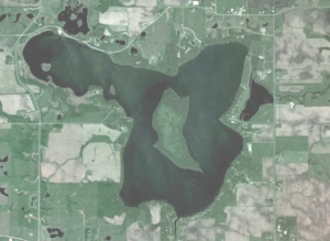
- Total acres: 837.56
- Littoral acres: 624
- Maximum Depth (ft): 14
- Water Clarity (ft): 5
- Abundance of Aquatic Plants: N/A
- Maximum Depth of Plant Growth (ft): 6
- Ditch 32 inlet (West) watershed: 10,167 acres
- Wolf Creek inlet (Southwest) watershed: 8,700 acres
- Number of houses on lakeshore: 85

LAKE MANAGEMENT PLAN (APRIL 2011)
WATER LEVEL DATA
Period of record: 05/05/1937 to 04/09/2010
# of readings: 434
Highest recorded: 1008.59 ft (06/27/1993)
Lowest recorded: 1002.68 ft (08/28/1941)
Recorded range: 5.91 ft
Last reading: 1005.41 ft (04/09/2010)
Ordinary High Water Level (OHW) elevation: 1005.4 ft
MAPS
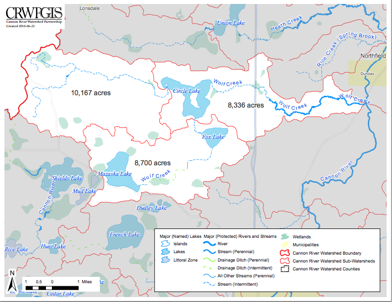 Watershed: Cannon River Watershed Partnership –
Circle Lake watershed map (June 2010)
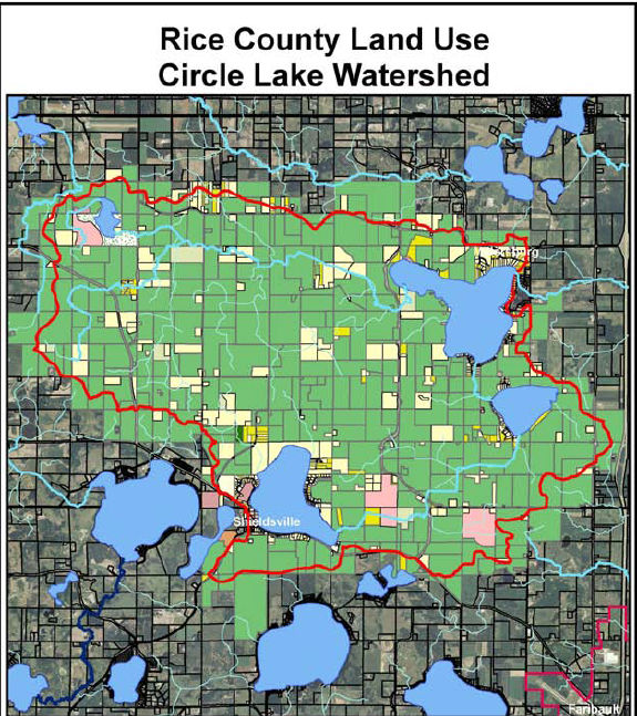 Watershed: Rice County –
Circle Lake watershed map (November 2010)
DNR SURVEYS
August 2012: DNR draft lake survey report for Circle Lake.
July 2010: DNR Invasive Species Department — report of inspection done in response to a lake association member who spotted Eurasion Milfoil in the Wolf Creek inlet at the 130th Street culvert.
June 2010: DNR Invasive Species Department — Invasive Species Point Intercept Study of Circle Lake. Over 100 points on the lake were sampled for Curly-Leaf Pondweed and other invasive species as well as native plants.
March 2010: DNR rough fish seining report for Circle Lake.
OTHER
Rice County: Water Resource Management documents, including the 2010-14 Local Water Management Plan
April 2001: MPCA report excerpts re: lake water transparency
1997(?): CRWP report re: turbidity monitoring
1996(?): Hydrologist report re: US Geological Survey activities
MORE RESOURCES
More resources on water management and environmental issues related to our mission:
- CANNON RIVER WATERSHED PARTNERSHIP (CRWP) – our lake association belongs to the CRWP, which is active in working on water quality issues in our region. Among the interesting items on the organization’s web site is its 2009 annual report and its November 2009 Watershed Watcher newsletter, which discusses septic issues and Clean Water Amendment grants.
- MINNESOTA WATERS – This is the umbrella organization for all lake associations in the state. Its web site is full of great resources for people who care about lake and water quality issues. Here are the two latest newsletters:
Confluence-11-10, Confluence-10-10. - Rice County Soil & Water Conservation District – September 2009 newsletter
- Minnesota Pollution Control Agency. Among the useful items on the MPCA’s web site is its summer issue of Environment magazine, which has an interesting discussion on page 16 about the cost of cleaning up a lake versus preventing its degradation in the first place, and the Fall 2001 issue, which discusses how long it takes a lake to recover after the incoming phosphorus is reduced.
- Minnesota Pollution Control Agency 1991 Lake Assessment Program Report
- Lakeshore Property Values and Water Quality – this June 2003 study, from the NRCS web site, is a study of lake water quality’s effect on lakeshore property values, completed in 2003 by Bemidji State University and the Mississippi Headwaters Board. They were able to correlate the rise and fall of property values with the increase and decrease iin Secchi depths. One lake (Leech) showed that a one meter increase in the Secchi depth, from 3m to 4m, would raise the property values by $424/frontage foot! So a 150 ft. lot price would rise $63,600! There was an even larger effect in the other direction. A one meter decrease in the Secchi depth would cause a property value drop of $594/frontage foot.
- Phosphorus: Sources, Forms, Impact on Water Quality
- Turbidity: Description, Impact on Water Quality, Sources, Measures
- Shore Land Management